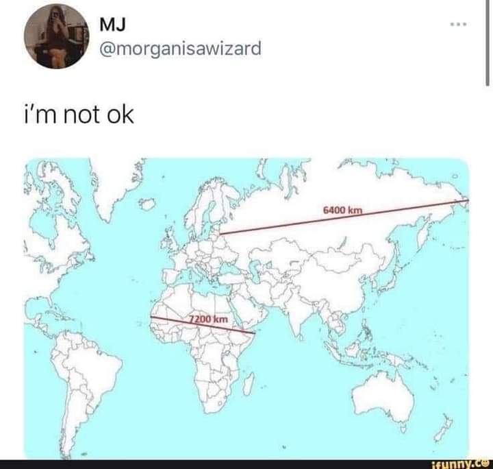
The Picard Maneuver to Funny: Home of the [email protected] • 7 months agoSide-effect of flattening a globestartrek.websiteimagemessage-square124arrow-up1922arrow-down112
arrow-up1910arrow-down1imageSide-effect of flattening a globestartrek.websiteThe Picard Maneuver to Funny: Home of the [email protected] • 7 months agomessage-square124
minus-square@[email protected]linkfedilink25•7 months agoWhat Greenland actually looks like is always wild. It looks like this massive arrow head that stretches so far to the east and west as you go north… When really it’s just like a normal island.
minus-square@[email protected]linkfedilink9•7 months agoAnd japans larger than it seems too when compared to the eastern US. Or the sheer size of the African continent
minus-square@[email protected]linkfedilink7•7 months agoStill pretty big though, about the same north-south as the u.s.
minus-square@[email protected]linkfedilink8•7 months agoI mean it is a big island. But on the standard map it looks like it’s as big as Mexico, Canada, and USA combined. When really it’s only about 30% larger than Alaska by square km.
minus-square@[email protected]linkfedilink2•7 months agoYou undersell Alaskas sheer square milage, it is a chunky boy
minus-square@[email protected]linkfedilink2•7 months agoAlaska is 1.7 m sq km and greenland is 2.2 m sq km. So I don’t think I’m too far off. So greenland is a bit bigger, when it’s crazy on the map they don’t look at all to be on the same scale. It’s even crazier for Mexico. Mexico is only a little bit smaller, but on the map it looks abysmally small in comparison.
minus-square@[email protected]linkfedilink1•7 months agoMy point is Alaska is 1/5 of the USA’s landmass. Calling Greenland a big island is underselling. If it were on its own in the Atlantic or pacific we’d argue over if it count as a dwarf continent
minus-square@[email protected]linkfedilink1•7 months agoI’m not saying it’s not a massive island. But just on standard maps it looks like it’s the size of Mexico, Canada, and US put together. When it’s just a bit bigger than Mexico.


What Greenland actually looks like is always wild.
It looks like this massive arrow head that stretches so far to the east and west as you go north…
When really it’s just like a normal island.
And japans larger than it seems too when compared to the eastern US.
Or the sheer size of the African continent
Still pretty big though, about the same north-south as the u.s.
I mean it is a big island.
But on the standard map it looks like it’s as big as Mexico, Canada, and USA combined.
When really it’s only about 30% larger than Alaska by square km.
You undersell Alaskas sheer square milage, it is a chunky boy
Alaska is 1.7 m sq km and greenland is 2.2 m sq km. So I don’t think I’m too far off.
So greenland is a bit bigger, when it’s crazy on the map they don’t look at all to be on the same scale.
It’s even crazier for Mexico. Mexico is only a little bit smaller, but on the map it looks abysmally small in comparison.
My point is Alaska is 1/5 of the USA’s landmass. Calling Greenland a big island is underselling. If it were on its own in the Atlantic or pacific we’d argue over if it count as a dwarf continent
I’m not saying it’s not a massive island.
But just on standard maps it looks like it’s the size of Mexico, Canada, and US put together.
When it’s just a bit bigger than Mexico.